Serengeti National Park

Go to Blogger edit html and find these sentences.Now replace these sentences with your own descriptions.

Ruaha National Park

Go to Blogger edit html and find these sentences.Now replace these sentences with your own descriptions.

Manyara National Park

Go to Blogger edit html and find these sentences.Now replace these sentences with your own descriptions.

Serengeti National Park

Go to Blogger edit html and find these sentences.Now replace these sentences with your own descriptions.

Udizungwa National Park

Go to Blogger edit html and find these sentences.Now replace these sentences with your own descriptions.

Mikumi National Park

Go to Blogger edit html and find these sentences.Now replace these sentences with your own descriptions.

Tuesday, 7 May 2019

Arusha National Park


Arusha National Park (ANAPA) is a gem of varied ecosystems and spectacular views of Mt. Meru, the crater that gives the region its name


Expand map


ANAPA Park Map, Click to Expand


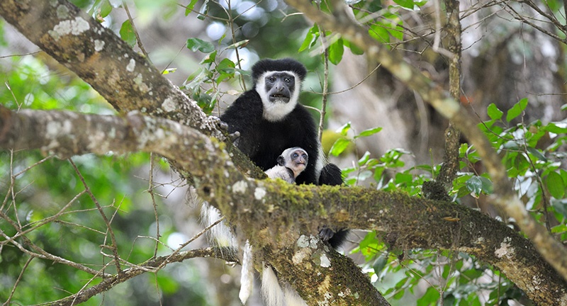
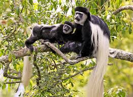
It is a popular destination for day trip visitors who are about to embark from the town of Arusha on longer northern circuit safaris. The small national park includes the slopes, summit, and ash cone of Mt. Meru, the Momela Lakes, Ngurdoto Crater, and the lush highland forests that blanket its lower slopes. Game viewing around the Momela Lakes is at a laid-back and quiet pace, and while passing through the forest many visitors stop to search for troupes of rare colubus monkeys playing in the canopy.


Climbing Mt. Meru or enjoying the smaller trails that criss-cross its lower slopes is a popular activity for visitors to Arusha National Park. The three-day trek to reach the crater’s summit is a quieter, and some say more challenging alternative than the famous peak of nearby Mount Kilimanjaro. Along the lower slopes, the paths to rivers and waterfalls create a relaxing day hike for visitors who don’t want to attempt the rather arduous climb. Ancient fig tree forests, crystal clear waters cascading from mountain streams, and a chance to spot colobus monkeys are the attractions and pleasures of Arusha National Park.


The closest national park to Arusha town – northern Tanzania’s safari capital – Arusha National Park is a multi-faceted jewel, often overlooked by safari goers, despite offering the opportunity to explore a beguiling diversity of habitats within a few hours.


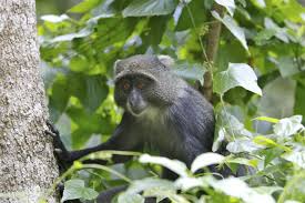
The entrance gate leads into shadowy montane forest inhabited by inquisitive blue monkeys and colourful turacos and trogons – the only place on the northern safari circuit where the acrobatic black-and-white colobus monkey is easily seen. In the midst of the forest stands the spectacular Ngurdoto Crater, whose steep rocky cliffs enclose a wide marshy floor dotted with herds of buffalo and warthog.


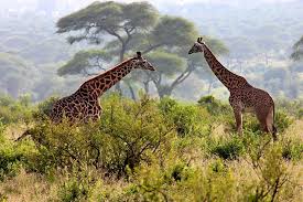
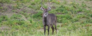
Further north, rolling grassy hills enclose the tranquil beauty of the Momela Lakes, each one having a different hue of green or blue. There are shallows sometimes tinged pink with thousands of flamingos. The lakes support a rich selection of resident and migrant waterfowl, and also shaggy waterbucks that display their large lyre-shaped horns on the watery fringes. Giraffes glide across the grassy hills, between grazing zebra herds, whilst pairs of wide-eyed dik-dik dart into scrubby bush like overgrown hares on spindly legs.


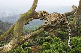
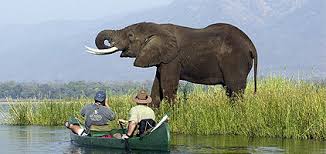
Although elephants are uncommon in Arusha National Park, and lions are absent altogether, leopards and spotted hyenas may be seen slinking around in the early morning and late afternoon. It is also at dusk and dawn that the veil of cloud on the eastern horizon is most likely to clear, revealing the majestic snow-capped peaks of Kilimanjaro, which is only 50km (30 miles) away.

But it is Kilimanjaro’s unassuming cousin, Mount Meru – the fifth highest mountain in Africa at 4,566 metres (14,990 feet) – that dominates the park’s horizon. With its peaks and eastern foot slopes protected within the national park, Meru offers unparalleled views of its famous neighbour, while also forming a rewarding hiking destination in its own right.


Passing first through wooded savannah where buffalos and giraffes are frequently encountered, the ascent of Meru leads into forests aflame with red-hot pokers and dripping with Spanish moss, before reaching highly open heath spiked with giant lobelias. Everlasting flowers cling to the alpine desert, as delicately-hoofed klipspringers mark the hike’s progress. Astride the craggy summit, Kilimanjaro stands unveiled, blushing in the sunrise.


Size

552 sq km (212 sq miles).
Image result for arusha national parkImage result for arusha national park
Image result for arusha national park

Saturday, 4 May 2019

Mount Kilimanjaro trekking ( Trekk with Us anytime) Machame route

Machame route 6-7 days

Itinerary

DAY 1  Machame Gate to Machame Camp

Elevation: 5,380 ft to 9,350 ft Distance: 11 km/7 miles Hiking Time: 5-7 hours Habitat: Rain Forest The drive from Moshi to the Machame Gate takes about 50 minutes. The journey passes through the village of Machame which is located on the lower slopes of the mountain. As we leave the park gate, we walk through the dense rain forest on a winding trail up a ridge until we reach the Machame Camp.

DAY 2  Machame Camp to Shira 2 Camp

Elevation: 9,350 ft to 12,500 ft Distance: 5 km/3 miles Hiking Time: 4-6 hours Habitat: Heath We leave the glades of the rain forest and continue on an ascending path up to a steep, rocky ridge. On the Shira Plateau, we pass through heather and open moorlands, then cross a large river gorge to Shira 2 Camp.

DAY 3  Shira 2 Camp to Lava Tower

Elevation: 12,500 ft to 15,190 ft Distance: 7 km/4 miles Hiking Time: 4-5 hours Habitat: Alpine Desert Lava Tower to Barranco Camp Elevation: 15,190 ft to 13,044 ft Distance: 3 km/2 miles Hiking Time: 2-3 hours Habitat: Alpine Desert We continue to the east up a ridge and then head southeast towards the Lava Tower a 300 ft tall volcanic rock formation. We descend down to Barranco Camp through the strange but beautiful Senecio Forest to an altitude of 13,000 ft. Although you begin and end the day at the same elevation, the time spent at higher altitude is very beneficial for acclimatization

DAY 4  Barranco Camp to Karanga Camp

Elevation: 13,044 ft to 13,106 ft Distance: 5 km/3 miles Hiking Time: 4-5 hours Habitat: Alpine Desert We begin the day by descending into a ravine to the base of the Great Barranco Wall. Then we climb the non-technical but steep, nearly 900 ft cliff. From the top of the Barranco Wall we cross a series of hills and valleys until we descend sharply into Karanga Valley. One more steep climb up leads us to Karanga Camp. This is a shorter day meant for acclimatization

DAY 5  Karanga Camp to Barafu Camp

Elevation: 13,106 ft to 15,331 ft Distance: 4 km/2 miles Hiking Time: 4-5 hours Habitat: Alpine Desert We leave Karanga and hit the junction which connects with the Mweka Trail. We continue up to the rocky section to Barafu Hut. At this point, you have completed the Southern Circuit, which offers views of the summit from many different angles. Here we make camp, rest and enjoy an early dinner to prepare for the summit day. The two peaks of Mawenzi and Kibo are viewable from this position.

DAY 6  Barafu Camp to Uhuru Peak

Elevation: 15,331 ft to 19,341 ft Distance: 5 km/3 miles Hiking Time: 7-8 hours Habitat: Arctic Uhuru Peak to Mweka Camp Elevation: 19,341 ft to 10,065 ft Distance: 12 km/7 miles Hiking Time: 4-6 hours Habitat: Rain Forest Very early in the morning (around midnight), we begin our push to the summit. This is the most mentally and physically challenging portion of the trek. The wind and cold at this elevation and time of day can be extreme. We ascend in the darkness for several hours while taking frequent, but short, breaks. Near Stella Point (18,900 ft), you will be rewarded with the most magnificent sunrise you are ever likely to see coming over Mawenzi Peak. Finally, we arrive at Uhuru Peak- the highest point on Mount Kilimanjaro and the continent of Africa From the summit, we now make our descent continuing straight down to the Mweka Hut camp site, stopping at Barafu for lunch. The trail is very rocky and can be quite hard on the knees; trekking poles are helpful. Mweka Camp is situated in the upper forest and mist or rain can be expected in the late afternoon. Later in the evening, we enjoy our last dinner on the mountain and a well-earned sleep

DAY 7  Mweka Camp to Mweka Gate

Elevation: 10,065 ft to 5,380 ft Distance: 10 km/6 miles Hiking Time: 3-4 hours Habitat: Rain Forest On our last day, we continue the descent to Mweka Gate and collect the summit certificates. At lower elevations, it can be wet and muddy. From the gate, we continue another hour to Mweka Village. A vehicle will meet us at Mweka Village to drive us back to the hotel in Moshi

Recommended Gears List

Pair of hiking sticks
One (1) - Hiking Boots, warm, waterproof1 headlight torch with extra batteries.
One (1) - Sleeping Bag, warm, four seasons
One (1) -Trekking Poles, collapsable highly recommended
One (1) - Head lamp, with extra batteries 
One (1) - Duffel bag, 50-90L capacity, for porters to carry your equipment
One (1) - Daypack, 30-35L capacity, for you to carry your personal gear may be rented on location
One (1 )- Gym Shoes to wear at camp optional
Tree (3) - Socks wool or synthetic
One (1) - Gaiters waterproof optional

Trip Receipt Passport  Visa (available at JRO)
Immunization Papers
Insurance Document
One (1) - Brimmed Hat, for sun protection 
One (1) - Knit Hat, for warmth
One (1) - Balaclava or Buff, for face overage - optional
One (1) - Gloves, warm waterproof recommended
One (1) - Gloves, thin

1 Camera with extra batteries.
One (1) - Waterproof Jacket, breathable with hood 
One (1) - Insulated Jacket, synthetic or down 
One (1) - Soft Jacket, fleece or soft-shell
Two (2) - Long Sleeve Shirt, light-weight, moisture-wicking fabric
 One (1) - Short Sleeve Shirt, light-weight, moisture-wicking fabric 
One (1) - Waterproof Pants, breathable side zipper recommended 
Two (2 )- Hiking Pants
One (1)- Fleece Pants
One (1) - Shorts --optional
One (1) - Long Underwear, moisture-wicking fabric 
Three (3) - Underwear, moisture-wicking fabric recommended 
Two (2) - Sport Bra --women 

Toiletries
Prescriptions Sunscreen 
Lip Balm 
Insect Repellent, 
containing DEETFirst Aid KitHand Sanitizer Wet Wipes - recommendedSnacks, light-weight, high calorie, high energy-optional

Electrolytes, powder or tablets -optional
One (1) 1 powerbank
One (1) - Sunglasses or Goggles
One (1) - Backpack Cover, waterproof optional
One (1) - Water Bottle (Nalgene, 32 oz 
One (1) - Water Bladder (Camelbak type, 3 liters 
One (1) - Towel, lightweight, quick-dry ptional
One (1) - Pee Bottle, to avoid leaving tent at night --recommended 

Stuff Sacks, Dry Bags or Plastic Bags, various sizes, to keep gear dry and separate


Mount Kilimanjaro trekking ( Trekk with us anytime) Marangu Route

Marangu Route 4 - 7 Days

Itinerary
DAY 1 Marangu Gate to Mandara Hut
Elevation (ft): 6,046 ft to 8,858 ft Distance: 8 km/5 miles Hiking Time: 4-5 hours Habitat: Rain Forest We depart Moshi for Marangu Gate for the necessary formalities before beginning our trek. The hiking trail begins by ascending a beautiful, tropical rain forest. At the upper edge of the forest line, we have the opportunity to see blue monkeys. The trail then widens to expose beautiful hillsides until we reach Mandara Hut
DAY 2 Mandara Hut to Horombo Hut
Elevation (ft): 8,858 ft to 12,205 ft Distance: 12 km/7 miles Hiking Time: 6-8 hours Habitat: Heath We start the day continuing through the forest until the trail opens into high moorland. We may get our first views of Kibo and Mawenzi peaks two of the three volcanic peaks that make up the summit of Kilimanjaro
DAY 3 Horombo Hut to Mawenzi Ridge
Elevation (ft): 12,205 ft to 14,400 ft Distance: 5 km/3 miles Hiking Time: 2-3 hours Habitat: Heath Mawenzi Ridge to Horombo Hut Elevation (ft): 14,400 ft to 12,205 Distance: 5 km/3 miles Hiking Time: 1-2 hours Habitat: Heath This is an extra day meant for acclimatization and can be spent day hiking on Mawenzi Ridge. The unique landscape offers motivating views of Kibo and Mawenzi. After spending a few moments exploring the area we head back to Horombo Hut
DAY 4 Horombo Hut to Kibo Hut
Elevation (ft): 12,205 ft to 15,430 ft Distance: 10 km/6 miles Hiking Time: 6-8 hours Habitat: Alpine Desert We climb gradually, then cross the lunar desert of the “Saddle” between Mawenzi and Kibo. Our camp, Kibo Hut, sits at the bottom of the Kibo crater wall. Once here we rest, enjoy an early dinner to prepare for the summit day
DAY 5 Kibo Hut to Uhuru Peak
Elevation (ft): 15,430 ft to 19,341 ft Distance: 6 km/4 miles Hiking Time: 6-8 hours Habitat: Arctic Uhuru Peak to Horombo Hut Elevation (ft): 19,341 ft to 12,250 ft Distance: 16 km/10 miles Hiking Time: 4-5 hours Habitat: Heath Very early in the morning (around midnight), we begin our push to the summit. This is the most mentally and physically challenging portion of the trek. The wind and cold at this elevation and time of day can be extreme. We ascend in the darkness for several hours while taking frequent, but short, breaks. At Gilman’s point (18,600 ft), you will be rewarded with the most magnificent sunrise you are ever likely to see coming over Mawenzi Peak. Finally, we arrive at Uhuru Peak- the highest point on Mount Kilimanjaro and the continent of Africa After spending a few moments taking in the plains of Africa and your accomplishment, we descend to Horombo Hut. Later in the evening, we enjoy our last dinner on the mountain and a well-earned sleep
DAY 6 Horombo Hut to Marangu Gate
Elevation (ft): 12,205 ft to 6,046 ft Distance: 20 km/12 miles Hiking Time: 5-7 hours Habitat: Rain Forest On our last day, we have a long trek mostly downhill through the tropical rainforest. Once at the park headquarters at Marangu gate, we collect our summit certificates. A vehicle will meet us here and drive us back to the hotel in Moshi


Recommended Gears List


Pair of hiking sticks
One (1) - Hiking Boots, warm, waterproof
1 headlight torch with extra batteries.
One (1) - Sleeping Bag, warm, four seasons
One (1) -Trekking Poles, collapsable highly recommended
One (1) - Head lamp, with extra batteries
One (1) - Duffel bag, 50-90L capacity, for porters to carry your equipment
One (1) - Daypack, 30-35L capacity, for you to carry your personal gear may be rented on location
One (1 )- Gym Shoes to wear at camp optional
Tree (3) - Socks wool or synthetic
One (1) - Gaiters waterproof optional
Trip Receipt
Passport
Visa (available at JRO)
Immunization Papers
Insurance Document
One (1) - Brimmed Hat, for sun protection
One (1) - Knit Hat, for warmth
One (1) - Balaclava or Buff, for face overage - optional
One (1) - Gloves, warm waterproof recommended
One (1) - Gloves, thin
1 Camera with extra batteries.
One (1) - Waterproof Jacket, breathable with hood
One (1) - Insulated Jacket, synthetic or down
One (1) - Soft Jacket, fleece or soft-shell
Two (2) - Long Sleeve Shirt, light-weight, moisture-wicking fabric
One (1) - Short Sleeve Shirt, light-weight, moisture-wicking fabric
One (1) - Waterproof Pants, breathable side zipper recommended
Two (2 )- Hiking Pants
One (1)- Fleece Pants
One (1) - Shorts --optional
One (1) - Long Underwear, moisture-wicking fabric
Three (3) - Underwear, moisture-wicking fabric recommended
Two (2) - Sport Bra --women
Toiletries
Prescriptions
Sunscreen
Lip Balm
Insect Repellent, containing DEET
First Aid Kit
Hand Sanitizer
Wet Wipes - recommended
Snacks, light-weight, high calorie, high energy-optional
Electrolytes, powder or tablets -optional
One (1) 1 powerbank
One (1) - Sunglasses or Goggles
One (1) - Backpack Cover, waterproof optional
One (1) - Water Bottle (Nalgene, 32 oz
One (1) - Water Bladder (Camelbak type, 3 liters
One (1) - Towel, lightweight, quick-dry ptional
One (1) - Pee Bottle, to avoid leaving tent at night --recommended
Stuff Sacks, Dry Bags or Plastic Bags, various sizes, to keep gear dry and separate


Mount Kilimanjaro trekking ( Trekk with us anytime( Umbwe Route)

Umbwe Route 6-7 Days


Itinerary
Day 1 – Umbwe Gate (1800m) – Bivouac Camp (2940m)
Habitat: Montane forest Hiking time: 5 hours After an early breakfast at your hotel, you will be picked up from Arusha (1400m) and driven to the Umbwe Gate. Here you can buy mineral water and will receive a packed lunch. At this time, the porters will organize and pack the belongings for the hike while you and your guide register with the Tanzania National Park (TANAPA). You will then begin your ascent into the rainforest. During this section of the hike, you should expect rain, mud, and fog. Also, be on the look out for wildlife, including Colobus monkeys! About halfway up the trail you will have a lunch break and you will reach the Bivouac Camp (2940m) in the late afternoon or early evening. The porters and chef, who move very fast up the mountain, will reach camp before you and set up your tents, boil drinking water, and prepare snacks for your arrival. After washing up, a hot dinner will be served. For overnight, mountain temperatures may drop to freezing so be prepared!
Day 2 – Bivouac Camp (2940m) – Barranco Camp (3950m)
Hiking time: 6 hours Habitat: Moorland After an early morning breakfast, you will start your ascent leaving the rain forest and entering the heathland moorland vegetation. In the moorland, you will spot exotic plants, including giant lobelia and groundsel. As you ascent, the trail provides a spectacular view of Mt. Kilimanjaro. The trail then flattens then descends into the Barranco Valley until you reach Barranco Camp. At this campsite, you will be next to a stream and have a spectacular view of the Western Breach and the Great Barranco Wall in the East. Similar to the first night, your tents will be set up prior to arriving at camp and the porters will prepare drinking and washing water for you. You will enjoy evening snacks then dinner prepared by our chef. Be prepared for a cold night as temperatures drop below freezing at this exposed camp.
Day 3 – Barranco Camp (3950m) – Lava Tower (4630m) – Arrow Glacier Camp (4800m)
Habitat: Moorland/Semi desert Following an early morning breakfast, you will leave the moorland environment and enter the semi desert and rocky landscape. After 5 hours of hiking east, you will be come face to face with the Lava Tower (4630m). Packed lunches are served at the Tower and hikers have the option of climbing the massive Lava Tower weather permitting. At this point of the hike, it is normal for hikers to start feeling the effects from the altitude including headaches and shortness of breath. After eating lunch at Lava Tower, hikers will scramble up the steep Class 2 trail to the Arrow Glacier Camp (4800m). Vegetation at Arrow Glacier is sparse and hikers are surrounded by stone scree. Snacks, dinner, and washing water will be provided, as hikers stay warm in their tents at this camp.
Day 4 – Arrow Glacier (4800m) – Crater (5700m)
Hiking time: 5 hours Habitat: Stone scree and ice-capped glacier After an early morning breakfast, hikers will continue to scramble up the Class 2 trail on rocks. During the rain season, an ice ax and crampons are required due to icy conditions. Hikers slowly ascend up the Western Breach to the Crater (5700m). Upon reaching the top of the crater, you will be amazed by the Northern Ice fields of Kilimanjaro with the Furtwangler Glacier directly in front of you. At the campsite, you have the option of completing a day hike to the infamous Ash Pit (1.5 hour) of Mt. Kilimanjaro. The ash pit is 340m across and 120m deep. After hiking, you will enjoy a warm dinner and be one of the few and fortunate hikers to stay at the inner, snow-covered crater of Mt. Kilimanjaro.
Day 5 – Summit Attempt Crater (5700m) – Uhuru Peak (5895m) – Mweka (3100m)
Hiking time: 2 hours to Uhuru and 7-8 hours to Mweka Distance: Approximately 7 kilometer ascent and 23 kilometer descent Habitat: Stone scree and ice-capped summit Your guide will wake you around 0400 for tea and biscuits. You will then begin your summit attempt. During the ascent, many hikers feel that this is the most mentally and physically challenging part of the climb. For about 2 hours, you will hike on a snow-covered trail to Uhuru Peak (5895m). Reaching the summit of Mt. Kilimanjaro is a lifetime accomplishment! You will be able to spend a short time on the summit taking photographs and drinking tea before the descent to Barafu begins. The hike down to Barafu Camp takes about 3 hours. At camp, you will rest and enjoy a hot lunch in the sun. After eating, you will continue descending down to Mweka Hut (3100m). The Mweka Trail will lead you through the scree and rocks to the moorland and eventually into the rain forest. Mweka Camp (3100m) is located in the upper rain forest, so fog and rain should be expected. You will have a dinner, wash, and rest soundly at camp.
Day 6 – Mweka Camp (3100m) – Mweka Gate (1980m)
Hiking time: 3 hours Distance: Approximately 15 kilometers Habitat: Forest Following a well-deserved breakfast, your staff will have a big celebration full of dancing and singing. It is here on the mountain that you will present your tips to the guide, assistant guides, chef(s), and porters. After celebrating, you will descend for three hours back to Mweka Gate. The National Park requires all hikers to sign their names to receive certificates of completion. Hikers who reached Stella Point (5685m) receive green certificates and hikers who reached Uhuru Peak (5895m) receive gold certificates. After receiving certificates, hikers will descend into the Mweka village for 1 hour (3 kilometers). You will be served a hot lunch then you will drive back to Arusha for long overdue showers and more celebrations.

Recommended Gears List
Pair of hiking sticks
One (1) - Hiking Boots, warm, waterproof
1 headlight torch with extra batteries.
One (1) - Sleeping Bag, warm, four seasons
One (1) -Trekking Poles, collapsable highly recommended
One (1) - Head lamp, with extra batteries
One (1) - Duffel bag, 50-90L capacity, for porters to carry your equipment
One (1) - Daypack, 30-35L capacity, for you to carry your personal gear may be rented on location
One (1 )- Gym Shoes to wear at camp optional
Tree (3) - Socks wool or synthetic
One (1) - Gaiters waterproof optional
Trip Receipt
Passport
Visa (available at JRO)
Immunization Papers
Insurance Document
One (1) - Brimmed Hat, for sun protection
One (1) - Knit Hat, for warmth
One (1) - Balaclava or Buff, for face overage - optional
One (1) - Gloves, warm waterproof recommended
One (1) - Gloves, thin
1 Camera with extra batteries.
One (1) - Waterproof Jacket, breathable with hood
One (1) - Insulated Jacket, synthetic or down
One (1) - Soft Jacket, fleece or soft-shell
Two (2) - Long Sleeve Shirt, light-weight, moisture-wicking fabric
One (1) - Short Sleeve Shirt, light-weight, moisture-wicking fabric
One (1) - Waterproof Pants, breathable side zipper recommended
Two (2 )- Hiking Pants
One (1)- Fleece Pants
One (1) - Shorts --optional
One (1) - Long Underwear, moisture-wicking fabric
Three (3) - Underwear, moisture-wicking fabric recommended
Two (2) - Sport Bra --women
Toiletries
Prescriptions
Sunscreen
Lip Balm
Insect Repellent, containing DEET
First Aid Kit
Hand Sanitizer
Wet Wipes - recommended
Snacks, light-weight, high calorie, high energy-optional
Electrolytes, powder or tablets -optional
One (1) 1 powerbank
One (1) - Sunglasses or Goggles
One (1) - Backpack Cover, waterproof optional
One (1) - Water Bottle (Nalgene, 32 oz
One (1) - Water Bladder (Camelbak type, 3 liters
One (1) - Towel, lightweight, quick-dry ptional
One (1) - Pee Bottle, to avoid leaving tent at night --recommended
Stuff Sacks, Dry Bags or Plastic Bags, various sizes, to keep gear dry and separate